|
|
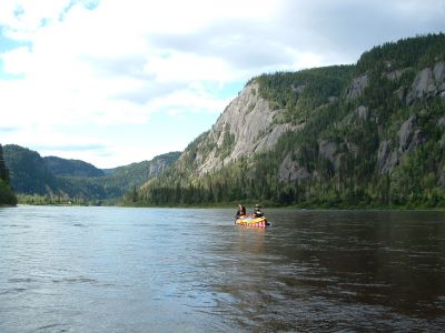
Moisie River
|
Marilyn and Dan paddling Moisie River.
http://www.geocities.com/lester_kovac/moisie.htm
http://maps.google.com/maps?q=50+41+44.18N,66+12+18.34W&t=h&z=12
http://www.panoramio.com/map/#lt=50.695606&ln=-66.205094&k=2&z=8&tab=2
http://www.topozone.com/map.asp?lat=50.695606&lon=-66.205094&symshow=y&size=x&u=4&s=50&datum=nad83
|
|


![1581LK_[74]_Dan_and_Marilyn_paddling_Moisie.jpg](albums/userpics/10087/thumb_1581LK_%5B74%5D_Dan_and_Marilyn_paddling_Moisie.jpg "Filename=1581LK_[74]_Dan_and_Marilyn_paddling_Moisie.jpg
Filesize=322KiB
Dimensions=1280x960
Date added=Jan 18, 2008")
![1668LC_[52.5]_Paul_and_Joe.jpg](albums/userpics/10087/thumb_1668LC_%5B52.5%5D_Paul_and_Joe.jpg "Filename=1668LC_[52.5]_Paul_and_Joe.jpg
Filesize=411KiB
Dimensions=1024x768
Date added=Jan 18, 2008")

![1733LK_[52.3]_Lynette_lunching.jpg](albums/userpics/10087/thumb_1733LK_%5B52.3%5D_Lynette_lunching.jpg "Filename=1733LK_[52.3]_Lynette_lunching.jpg
Filesize=319KiB
Dimensions=1280x960
Date added=Jan 18, 2008")
