Home
Login
CCR Gallery
Photos from users of myccr.com
MyCCR Home Page
Album list
Last uploads
Last comments
Most viewed
Top rated
My Favorites
Search
Home
>
Canoe Routes
>
Quebec
FILE 12/201
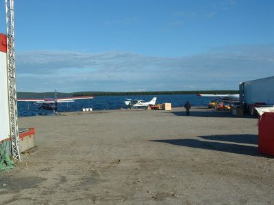
Air Saguenay base
Air Saguenay base on Lac Pau (Caniapiscau Reservoire)
http://www.panoramio.com/map/#lt=54.844319&ln=-69.882889&k=2&z=6&tab=2
http://www.topozone.com/map.asp?lat=54.844319&lon=-69.882889&s=50&symshow=y&size=x&u=4&datum=nad83
File information
Filename:
0247LK_Air_Saguenay.jpg
Album name:
lllynette
/
Quebec
Rating (1 votes):
(
Show details
)
Keywords:
Caniapiscau
/
Pau
/
airbase
Photo Credit:
Lester Kovac
Date:
July 29, 2007
Place Taken:
Lac Pau 54:50:39.54 N 69:52:58.4 W
Route Name:
Caniapiscau Charpentier Leaf
Filesize:
308 KiB
Date added:
Feb 15, 2008
Dimensions:
1280 x 960 pixels
Displayed:
1149 times
EXIF Image Height:
960 pixels
FlashPix Version:
version 1
ISO:
100
Resolution Unit:
Inch
Y Resolution:
72 dots per ResolutionUnit
YCbCrPositioning:
Datum Point
URL:
http://gallery.myccr.com/displayimage.php?pid=1534
Favorites:
Add to Favorites


![0238LC_[354]_Paddling_L3.jpg](albums/userpics/10087/thumb_0238LC_%5B354%5D_Paddling_L3.jpg "Filename=0238LC_[354]_Paddling_L3.jpg
Filesize=391KiB
Dimensions=1024x768
Date added=Jan 18, 2008")

![0275LK_[349]_Portaging_L5.jpg](albums/userpics/10087/thumb_0275LK_%5B349%5D_Portaging_L5.jpg "Filename=0275LK_[349]_Portaging_L5.jpg
Filesize=308KiB
Dimensions=1280x960
Date added=Jan 18, 2008")
![0325LK_[320]_L4.jpg](albums/userpics/10087/thumb_0325LK_%5B320%5D_L4.jpg "Filename=0325LK_[320]_L4.jpg
Filesize=315KiB
Dimensions=960x1280
Date added=Jan 18, 2008")
