CCR Gallery

Photos from users of myccr.com
Home > Canoe Routes > Ontario
Click to view full size image

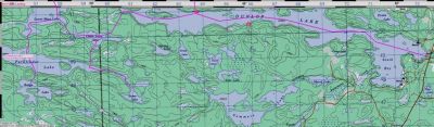
Public Landing at Dunlop Lake South Shore

Near Elliott Lake.
The south shore has been sold off for cottage lots, and there is now a public landing about 2/3 down the lake. The road is signed as leading to "Dunlop Shores" and the new parking lot is near holds maybe 30 cars. There is a (mediocre) camp site right at the portage leading to Ten Mile Lake.

resizedIMG_0035.JPG Image-51.jpg Image-42.jpg Dunlop_Loop_S-small.jpg Opeongo_Outfitters_water_taxi.jpg matabitchuan_sunset.JPG Czar_hauls_pack.jpg
File information
Filename:Dunlop_Loop_S-small.jpg
Album name:erhard / Ontario
Rating (1 votes):44444(Show details)
Filesize:57 KiB
Date added:Aug 19, 2008
Dimensions:755 x 222 pixels
Displayed:736 times
EXIF Image Height:222 pixels
Resolution Unit:Inch
Y Resolution:72 dots per ResolutionUnit
YCbCrPositioning:Center of Pixel Array
URL:http://gallery.myccr.com/displayimage.php?pid=1795
Favorites:Add to Favorites