Home
Login
CCR Gallery
Photos from users of myccr.com
MyCCR Home Page
Album list
Last uploads
Last comments
Most viewed
Top rated
My Favorites
Search
Home
>
Other Pics
>
Miscellaneous
FILE 274/363
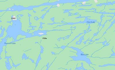
Fuzzy maps - crownland use atlas
This map has the most accurate representation of water vs dry land. But it's unlikely that you wil have it on you as you try to make your way across the bush.....
File information
Filename:
long-buzz-mcgee-crownlanduseatlas.jpg
Album name:
erhard
/
Miscellaneous
Rating (1 votes):
(
Show details
)
Filesize:
36 KiB
Date added:
Sep 12, 2008
Dimensions:
673 x 410 pixels
Displayed:
516 times
EXIF Image Height:
410 pixels
Resolution Unit:
Inch
Y Resolution:
72 dots per ResolutionUnit
YCbCrPositioning:
Center of Pixel Array
URL:
http://gallery.myccr.com/displayimage.php?pid=1883
Favorites:
Add to Favorites